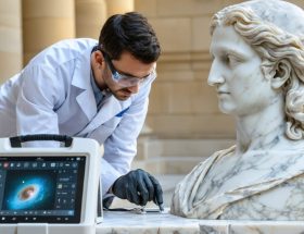
Three-dimensional geological modeling software transforms how restoration professionals document, analyze, and preserve historic stone structures by creating precise digital twins of deteriorating facades, ornamental details, and structural elements. These specialized tools capture millimeter-level accuracy across entire building surfaces, generating comprehensive spatial databases that track cracks, spalling, material loss, and weathering patterns invisible to traditional assessment methods.
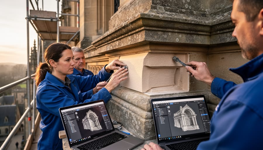
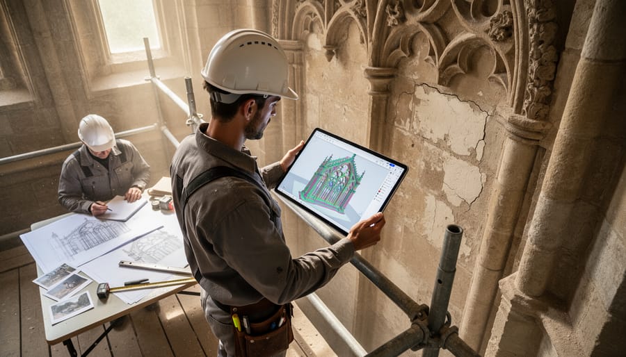
The technology bridges the gap between fieldwork and restoration planning by converting laser scans, photogrammetry data, and ground-penetrating radar readings into interactive 3D models. Restoration teams can virtually section through walls to examine substrate conditions, measure exact volumes of missing stone requiring replacement, and simulate proposed interventions before physical work begins. This digital-first approach reduces costly errors, enables precise material quantity calculations, and creates permanent historical records documenting pre-restoration conditions.
Modern geological modeling platforms specifically designed for built heritage differ substantially from mining or petroleum exploration software. They prioritize surface detail capture, support integration with Building Information Modeling systems, and offer analytical tools tailored to masonry deterioration assessment. Leading solutions range from cloud-based platforms requiring minimal technical expertise to advanced engineering suites demanding specialized training, making the technology accessible across project scales from single monument conservation to district-wide preservation initiatives.
Understanding which software aligns with specific restoration objectives, budget constraints, and team capabilities directly impacts project outcomes. The right modeling solution streamlines documentation workflows, improves stakeholder communication through visual clarity, and establishes data foundations supporting long-term maintenance planning. This guide examines practical applications, compares available platforms, and provides implementation frameworks helping restoration professionals leverage 3D geological modeling for superior stone preservation results.
Why Traditional Stone Restoration Methods Fall Short
Historic stone structures tell stories through their weathered surfaces, carved details, and time-worn textures. Yet for decades, restoration professionals have struggled to capture this complexity accurately using traditional documentation methods. While modern stone conservation techniques have evolved significantly, the documentation methods supporting them often haven’t kept pace.
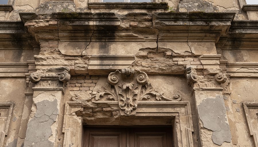
Hand measurements with tape measures and calipers provide basic dimensional data, but they fall dramatically short when dealing with irregular surfaces, intricate carvings, or extensive deterioration patterns. A conservator might record dozens of measurements, yet still miss critical details about how stone has eroded unevenly or where micro-fractures threaten structural integrity. Each measurement represents a single point in space, leaving vast gaps in understanding the complete geometry.
Photography offers visual records but lacks dimensional accuracy. A photograph can show what deterioration looks like but cannot capture the depth of material loss, the precise angle of a crack, or the three-dimensional relationships between damaged areas. Shadows, lighting variations, and perspective distortions further compromise accuracy. Restoration teams working from photographs often discover unexpected conditions once work begins, leading to costly project delays and design revisions.
Traditional 2D drawings compound these limitations by forcing three-dimensional complexity into flat representations. Architects and conservators must interpret multiple elevation views, sections, and details to mentally reconstruct the actual structure. This interpretation process introduces opportunities for error, particularly when documenting ornate architectural elements like capitals, cornices, or decorative reliefs. Details get simplified or lost entirely in translation.
These cumulative inaccuracies create serious consequences during restoration. Replacement stones may not fit properly, requiring expensive custom modifications. Historic profiles get approximated rather than precisely matched, compromising authenticity. Most critically, irreversible decisions about material removal or consolidation get made based on incomplete information. When documentation methods cannot capture what truly exists, restoration teams work partially blind, increasing risks to irreplaceable cultural heritage.
What 3D Geological Modeling Software Actually Does
Capturing Stone Deterioration Patterns
3D geological modeling software provides unprecedented precision in documenting various stone decay processes that compromise historic structures. Using high-resolution scanning technology, these systems capture erosion patterns down to millimeter-level accuracy, creating detailed maps of surface loss over time. The software identifies biological growth such as lichen, moss, and algae by detecting color variations and surface irregularities, allowing restorers to assess the extent of biological colonization.
Fracture networks and structural cracks are documented through depth mapping, revealing whether damage extends superficially or penetrates deep into the stone matrix. The software measures crack widths, lengths, and propagation patterns, providing quantitative data essential for stability assessments. Surface delamination and spalling are captured through comparative scans, showing material loss rates and helping predict future deterioration.
Salt crystallization damage, weathering crusts, and differential erosion patterns become visible through detailed surface topology analysis. This measurable documentation replaces subjective visual assessments with objective data, enabling restoration professionals to prioritize interventions based on severity and monitor treatment effectiveness through before-and-after comparisons. The resulting digital records become invaluable archives for long-term preservation planning.
Creating Accurate Stone Replacement Templates
One of the most valuable applications of 3D geological modeling software in stone restoration is creating precise templates for replacement pieces. When original stone elements are damaged beyond repair or missing entirely, fabricators need exact specifications to craft replacements that integrate seamlessly with existing stonework.
Digital models capture every contour, dimension, and surface variation of surrounding stones with millimeter-level accuracy. This detailed information translates directly into fabrication instructions, eliminating the guesswork that plagued traditional templating methods. Where craftsmen once relied on hand measurements and physical templates that could warp or shift, digital files provide a permanent, precise reference that can be shared instantly with stone suppliers and fabricators anywhere in the world.
The software generates various outputs tailored to different fabrication processes. CNC machine operators receive cutting paths and tool coordinates, while waterjet cutting systems use the digital profiles to guide their precision cutting. For more artisanal work, fabricators can produce full-scale physical templates from the digital model using large-format printers or CNC routers.
This technology proves especially valuable for complex architectural elements like curved balustrades, decorative cornices, or intricately carved capitals. The software captures undercuts, relief depths, and three-dimensional profiles that would be nearly impossible to measure and replicate accurately using conventional methods. The result is replacement stones that fit perfectly on the first attempt, reducing installation time, minimizing waste, and preserving the architectural integrity of historic structures.
The Leading Software Solutions for Stone Restoration Projects
Photogrammetry-Based Solutions
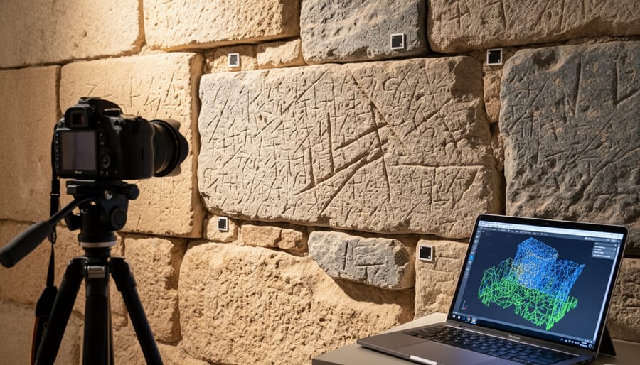
Photogrammetry-based software transforms ordinary photographs into precise three-dimensional models, making them invaluable tools for stone restoration documentation. These solutions work by analyzing multiple overlapping images of a structure from different angles, identifying common reference points, and calculating spatial relationships to build accurate geometric representations.
Agisoft Metashape stands out as a comprehensive photogrammetry platform widely adopted in heritage conservation projects. The software excels at processing large datasets from historical buildings, creating detailed surface models that capture every crack, weathered texture, and deterioration pattern in stone facades. Its ability to generate orthophotos—geometrically corrected images—allows restoration teams to create precise elevation drawings without physical measurements at dangerous heights.
RealityCapture offers faster processing speeds, particularly beneficial when documenting extensive stone structures under time constraints. The software’s GPU acceleration capabilities enable quick turnaround from field photography to usable 3D models, essential for projects requiring rapid assessment before weather conditions change or scaffolding rental periods expire.
Both platforms require minimal specialized equipment beyond a quality camera, making photogrammetry accessible compared to laser scanning alternatives. However, challenging lighting conditions, reflective polished stone surfaces, or featureless areas can present difficulties. The resulting models typically achieve millimeter-level accuracy when properly executed, sufficient for most restoration planning, condition monitoring, and archival documentation purposes.
These tools integrate seamlessly with traditional CAD software, allowing architects and restoration specialists to extract measurements, plan interventions, and communicate design intent effectively across project teams.
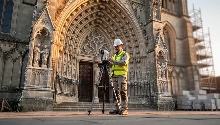
Laser Scanning Software
Point cloud processing software transforms raw laser scan data into actionable information for stone restoration projects. These specialized tools handle the massive datasets generated by 3D laser scanners, which can contain millions of individual measurement points captured from historic structures and monuments.
CloudCompare stands out as a powerful, open-source solution for processing point cloud data. This free software allows restoration professionals to clean, align, and analyze scans of stone facades, columns, and ornamental features. Its measurement tools enable precise documentation of weathering patterns, material loss, and structural deformation—essential information for developing restoration strategies. The software’s ability to compare multiple scans over time helps professionals track deterioration rates and evaluate the effectiveness of conservation treatments.
Leica Cyclone represents the industry standard for commercial point cloud processing. While more expensive than free alternatives, it offers robust tools specifically designed for architectural documentation. Cyclone excels at registering multiple scan positions into unified 3D models of complex stone structures. The software’s extraction features convert point clouds into accurate as-built drawings and cross-sections, which architects and engineers need for restoration planning.
For restoration professionals new to laser scanning, CloudCompare provides an accessible entry point without financial commitment. Projects requiring extensive documentation of large stone structures or those needing seamless integration with professional workflows may benefit from investing in Cyclone’s advanced capabilities. Both platforms support common file formats, ensuring compatibility with other modeling and analysis software used throughout the restoration process.
Integrated CAD Solutions
Integrated CAD solutions bridge the gap between geological analysis and practical restoration design. Rhino 3D excels at creating detailed three-dimensional models that combine geological survey data with architectural elements, allowing restoration teams to visualize how stone degradation affects structural integrity. Its precision modeling capabilities make it particularly valuable when planning interventions for historic stone facades or sculptural elements.
AutoCAD Civil 3D offers robust tools for integrating subsurface geological information with building plans, essential when assessing foundation conditions in stone structures. These platforms enable architects and engineers to layer geological data—such as stone composition, moisture patterns, and structural weaknesses—directly onto restoration drawings. This integration streamlines communication between geologists, architects, and contractors, reducing errors and ensuring that restoration approaches account for the specific geological characteristics of the stone materials involved in each project.
Real-World Impact: Stone Restoration Projects Transformed by 3D Modeling
Historic Building Façade Restoration
The renovation of the 1892 Beaux-Arts courthouse in Philadelphia demonstrates how 3D geological modeling software revolutionized historic stone restoration. The building’s limestone façade had deteriorated significantly, with over 300 decorative elements requiring assessment for repair or replacement.
The restoration team employed terrestrial laser scanning to capture the entire façade at millimeter-level accuracy, creating a comprehensive digital model of every carved detail, column capital, and ornamental feature. This digital documentation proved invaluable when distinguishing between original Indiana limestone and later cement repairs from poorly executed 1960s interventions.
By analyzing the 3D model alongside geological data about the original quarry source, architects identified which deteriorated sections could be conserved and which required replacement. The software enabled precise measurements of each carved rosette, corbel, and architrave, ensuring replacement stones matched original dimensions exactly. Stone carvers used these digital templates to recreate intricate details that would have been impossible to replicate from photographs alone.
The technology also revealed subtle settling patterns in the foundation that had caused stress fractures in specific façade sections. This discovery allowed engineers to address underlying structural issues before installing new stonework, following preservation ethics that prioritize understanding before intervention.
The completed restoration seamlessly integrated 127 replacement limestone pieces with conserved original elements. Without 3D modeling, distinguishing authentic craftsmanship from deteriorated stone would have relied solely on subjective visual assessment, potentially leading to unnecessary replacement of salvageable historic material.
Monument Conservation Under Time Constraints
When a historic limestone monument in Prague began showing alarming deterioration patterns in 2019, conservators faced a critical challenge: traditional documentation methods would take weeks, but structural instability demanded immediate intervention. The solution came through advanced 3D geological modeling software that compressed months of assessment work into just three days.
The conservation team deployed terrestrial laser scanning technology to capture the monument’s entire surface geometry, recording millions of data points with sub-millimeter accuracy. This rapid documentation proved invaluable as it revealed hidden fracture networks and differential weathering patterns invisible to conventional photography or manual measurements. Within 72 hours, engineers had a complete digital twin showing exactly where emergency stabilization was needed most urgently.
The 3D model enabled the team to prioritize interventions strategically. Areas with active spalling and structural weakness received immediate temporary support, while the detailed surface data informed material selection for eventual restoration. Perhaps most significantly, the software allowed conservators to simulate various restoration approaches virtually before touching the physical monument, minimizing risk to the irreplaceable stone.
Two years later, when full restoration began, the original 3D documentation provided an invaluable baseline. Conservators could track exactly how weathering had progressed during the interim period and measure the effectiveness of temporary stabilization measures. The software also facilitated precise stone replacement calculations, reducing material waste and ensuring historically appropriate repairs.
This case demonstrates how 3D geological modeling transforms emergency heritage conservation from reactive crisis management into informed, strategic intervention. For restoration professionals and building managers facing similar time-sensitive projects, these digital tools offer both immediate practical benefits and long-term documentation value that traditional methods simply cannot match.
What Stone Restoration Professionals Need to Get Started
Essential Hardware and Technology
Getting started with 3D geological modeling for stone restoration requires careful consideration of hardware capabilities. At minimum, you’ll need a modern computer with a dedicated graphics card, at least 16GB RAM, and a multi-core processor. Entry-level setups suitable for basic documentation and visualization typically range from $1,200 to $2,000.
For professionals handling complex restoration projects, mid-range workstations ($3,000-$5,000) offer improved performance with 32GB RAM, professional-grade GPUs like NVIDIA Quadro or AMD Radeon Pro, and faster processors. These systems handle larger datasets and enable real-time model manipulation without lag.
High-end configurations ($7,000+) become necessary for extensive historical building documentation or working with massive point cloud datasets. These include workstation-class components, 64GB+ RAM, and specialized graphics cards designed for CAD applications.
Beyond the computer itself, budget for essential peripherals: a quality mouse or 3D navigation device ($100-$400), calibrated monitor ($300-$800), and external storage for backup ($150-$300). Cloud storage subscriptions ($10-$50 monthly) ensure data security and team collaboration. Total initial investment typically ranges from $2,000 for basic setups to $10,000+ for professional-grade systems, with software licensing as an additional ongoing expense.
Building Technical Expertise
Transitioning to 3D geological modeling software requires a structured approach to skill development. Most restoration professionals find success by starting with foundational photogrammetry principles before advancing to specialized geological applications. Many software providers offer free introductory courses that cover basic scanning techniques, point cloud processing, and model interpretation specific to natural stone documentation.
Online learning platforms provide targeted training paths for heritage conservation professionals. Courses typically begin with equipment operation and data capture protocols, then progress to mesh generation, texture mapping, and defect analysis. Leading manufacturers like Agisoft, Bentley Systems, and Trimble offer certification programs that validate competency in their respective platforms, enhancing professional credibility.
Hands-on workshops remain invaluable for mastering practical applications. Industry conferences and stone restoration associations frequently host training sessions where professionals can practice scanning techniques on actual deteriorated stonework. These sessions allow participants to troubleshoot common challenges like reflective surfaces, shadowed areas, and scale accuracy under expert guidance.
Building proficiency demands consistent practice. Many professionals recommend dedicating 10-15 hours to learning basic scanning workflows, followed by supervised project work. Case studies demonstrate that restoration teams achieve operational competency within three months when combining structured training with real-world applications. Investing in continued education through webinars and user community forums ensures practitioners stay current with evolving software capabilities and best practices in digital stone documentation.
The Future of Stone Preservation Through Digital Technology
The preservation landscape is transforming rapidly as artificial intelligence and machine learning enter the field. AI-assisted damage analysis systems can now scan deteriorated stonework and identify patterns invisible to the human eye, predicting where future problems will emerge before they become critical. These systems learn from thousands of restoration projects, helping professionals prioritize interventions based on actual risk rather than guesswork. Virtual restoration planning tools allow teams to test different conservation approaches digitally before touching historic materials, reducing costly mistakes and preserving more original fabric.
Digital archives are becoming insurance policies for irreplaceable heritage. When natural disasters, conflict, or neglect threaten historic structures, comprehensive 3D models serve as permanent records. If physical buildings are damaged or destroyed, these digital twins preserve architectural knowledge for future generations and enable accurate reconstruction if desired. Major institutions worldwide are building collaborative databases where restoration professionals share detailed scans of significant stone structures, creating a global safety net for architectural heritage.
The democratization of this technology marks perhaps the most significant shift. Cloud-based platforms and smartphone-compatible scanning tools are eliminating entry barriers that once limited digital documentation methods to well-funded projects. Individual craftspeople can now create professional-grade 3D models using tablet devices, while subscription-based software eliminates prohibitive upfront costs. Open-source training resources and online communities help smaller restoration firms develop technical skills without expensive consultants.
This accessibility is particularly valuable for documenting vernacular architecture and modest historic buildings that major institutions might overlook. Local stonemasons can now preserve knowledge of regional techniques and materials with the same tools used on cathedrals and monuments. As processing power increases and costs decrease, even heritage-conscious homeowners can create detailed records of their historic stonework, ensuring craftsmanship details survive regardless of future renovations or changes in ownership.
For professionals committed to preserving our stone heritage, 3D geological modeling software has transitioned from optional enhancement to essential tool. The evidence is clear: projects utilizing these digital systems consistently deliver superior accuracy, dramatically reduced timelines, and documentation that serves both immediate restoration needs and long-term preservation goals.
The benefits extend beyond technical improvements. By creating precise digital twins of stone structures, restoration teams minimize invasive intervention, reduce material waste, and make informed decisions backed by comprehensive spatial data rather than assumptions. This precision translates directly to cost savings and better outcomes for clients, while protecting irreplaceable historic stonework from trial-and-error approaches that can cause permanent damage.
Perhaps most importantly, 3D modeling creates a permanent digital archive of our stone architecture. As natural weathering, environmental stresses, and time continue affecting these structures, these detailed records become invaluable baselines for future restoration efforts. Combined with sustainable restoration practices, this technology helps ensure authenticity across generations of preservation work.
The learning curve and initial investment may seem daunting, but the alternative—continuing with outdated documentation methods while competitors advance—carries far greater risk. Stone structures that have stood for centuries deserve the best tools modern technology offers. By embracing 3D geological modeling, restoration professionals don’t just improve their services; they become active guardians of architectural heritage, ensuring that magnificent stone craftsmanship endures for future generations to appreciate and study.